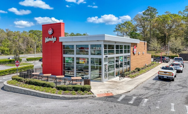
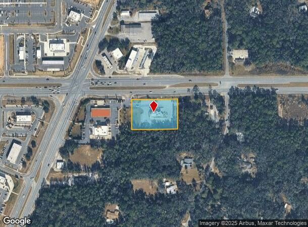
Property Record
2900 W Norvell Bryant Hwy, Lecanto, FL 34461

NEARBY LISTINGS FOR SALE OR LEASE
Property Detail
2900 W Norvell Bryant Hwy
Homosassa Springs, FL
Crystal River Country Estates
18E-18S-22-0010-00000-1370
CRYSTAL RIVER CTRY ESTS PB 7 PG 147 A PTN OF LOTS 94 95 96 AND 136. (LR-99-14 ACCEPTED 6/16/99 OR BK 1316 PG 2263 -2269) DESCR AS FOLL: PCL A: BEG AT THE NW COR OF LT 94 SD PT BEING ON THE S R/W LN OF CO RD 486 SD PT ALSO BEING 50 FT FROM MEASURED AT
Restaurantdrivein
Citrus
X
Florida
12017C0213D
94
2024
1.47 AC
2025
Florida Central North Area
450704
Other Market Areas
2,553 SF
DEMOGRAPHICS near 2900 W Norvell Bryant Hwy
1 Mile
3 Mile
5 Mile
2024 Total Population
1,262
22,629
46,909
2029 Population
1,403
25,323
52,516
Pop Growth 2024-2029
+ 11.17%
+ 11.91%
+ 11.95%
Average Age
54
54
53
2024 Total Households
546
10,261
20,995
HH Growth 2024-2029
+ 10.99%
+ 11.75%
+ 11.73%
Median Household Inc
$44,296
$50,087
$53,744
Avg Household Size
2.10
2.10
2.10
2024 Avg HH Vehicles
2.00
2.00
2.00
Median Home Value
$252,343
$245,391
$245,503
Median Year Built
1995
1991
1992
Nearby Places
Map Layers
Map Styles
 Street
 Aerial
- Restaurants
- Banks
- Shops
- Fitness
- Groceries
SALE & LEASE HISTORY
LISTING DATE
SALE/LEASE

Mar 16, 2018
For Sale
Mar 08, 2018
For Sale
Jun 04, 2018
For Sale
Aug 09, 2018
For Sale
Aug 06, 2018
For Sale
Apr 26, 2018
For Sale
Apr 09, 2018
For Sale
Nearby Properties
Address
Land Use
TOTAL SIZE
Lot Size
Zoning
Address
Land Use
TOTAL SIZE
Lot Size
Zoning
840,664 SF
6.64 AC
PDR
Address
Land Use
TOTAL SIZE
Lot Size
Zoning
405,045 SF
18.52 AC
PSI
Address
Land Use
TOTAL SIZE
Lot Size
Zoning
135,334 SF
11.45 AC
GNC
Address
Land Use
TOTAL SIZE
Lot Size
Zoning
901,824 SF
14.37 AC
GNC
Address
Land Use
TOTAL SIZE
Lot Size
Zoning
114,484 SF
20.07 AC
PDR
Address
Land Use
TOTAL SIZE
Lot Size
Zoning
92,500 SF
5.11 AC
PSO
Address
Land Use
TOTAL SIZE
Lot Size
Zoning
66,513 SF
31.85 AC
PSI
Address
Land Use
TOTAL SIZE
Lot Size
Zoning
167,220 SF
9.09 AC
GNC
Address
Land Use
TOTAL SIZE
Lot Size
Zoning
664,950 SF
20.21 AC
IND
Address
Land Use
TOTAL SIZE
Lot Size
Zoning
300,060 SF
8.74 AC
PDR
Address
Land Use
TOTAL SIZE
Lot Size
Zoning
178,134 SF
10.77 AC
PDR
Address
Land Use
TOTAL SIZE
Lot Size
Zoning
98,862 SF
18.36 AC
RUR
Address
Land Use
TOTAL SIZE
Lot Size
Zoning
57,652 SF
11.85 AC
GNC
Address
Land Use
TOTAL SIZE
Lot Size
Zoning
447,538 SF
7.06 AC
PDR
Address
Land Use
TOTAL SIZE
Lot Size
Zoning
345,488 SF
5.87 AC
PDR
Address
Land Use
TOTAL SIZE
Lot Size
Zoning
55,949 SF
4.71 AC
GNC
Address
Land Use
TOTAL SIZE
Lot Size
Zoning
22.87 AC
GNC
Address
Land Use
TOTAL SIZE
Lot Size
Zoning
214,450 SF
9.18 AC
GNC
Address
Land Use
TOTAL SIZE
Lot Size
Zoning
42,134 SF
4.52 AC
GNC
Address
Land Use
TOTAL SIZE
Lot Size
Zoning
164,940 SF
10.36 AC
PDR
Address
Land Use
TOTAL SIZE
Lot Size
Zoning
53,425 SF
5.18 AC
PDR
Address
Land Use
TOTAL SIZE
Lot Size
Zoning
13,025 SF
1.93 AC
PDR
Address
Land Use
TOTAL SIZE
Lot Size
Zoning
155,752 SF
32.74 AC
PDR
Address
Land Use
TOTAL SIZE
Lot Size
Zoning
86,553 SF
7.78 AC
GNC
Address
Land Use
TOTAL SIZE
Lot Size
Zoning
54,753 SF
14.95 AC
PSI
Address
Land Use
TOTAL SIZE
Lot Size
Zoning
76,562 SF
212.56 AC
PDR
Address
Land Use
TOTAL SIZE
Lot Size
Zoning
36,430 SF
14.26 AC
GNC
Address
Land Use
TOTAL SIZE
Lot Size
Zoning
5,526 SF
4.72 AC
GNC
Address
Land Use
TOTAL SIZE
Lot Size
Zoning
20,492 SF
2.61 AC
GNC
Address
Land Use
TOTAL SIZE
Lot Size
Zoning
23,540 SF
8.97 AC
PSO
The World's #1 Commercial Real Estate Marketplace
Connect with us
© 2025 CoStar Group
The information above has been obtained from sources believed reliable. While we do not doubt its accuracy we have not verified it and make no guarantee, warranty or representation about it. It is your responsibility to independently confirm its accuracy and completeness. Any projections, opinions, assumptions, or estimates used are for example only and do not represent the current or future performance of the property. The value of this transaction to you depends on tax and other factors which should be evaluated by your tax, financial, and legal advisors. You and your advisors should conduct a careful, independent investigation of the property to determine to your satisfaction the suitability of the property for your needs.